
We look forward to welcoming you to our school community here at East Fremantle Primary School.
All children from Pre-Primary to Year 12 are guaranteed a place at their local public school (please click here to check your residential address)
The map below clearly defines the area for which East Fremantle Primary School is the local public school.
You can complete an Online Application form for Enrolment for your child to attend East Fremantle Primary School using the links below and email to us at eastfremantle.ps@education.wa.edu.au
**If you are inquiring about Kindergarten for 2024, please contact us directly on 9432 1200**
If there are more applications for Kindy enrolment than places available, all Kindy applications will be categorised and places offered in order, Categories 1-4 until all available spots are filled:
Category 1: Student is living within the school’s catchment zone with sibling already enrolled at the school
Category 2: Student is living within the school’s catchment zone without a sibling already enrolled at the school
Category 3: Student is not living within the school’s catchment zone but has a sibling already enrolled at the school
Category 4: Student is not living within the school’s catchment zone and does not have a sibling already enrolled at the school
2025 YR 1-YR 6 APPLICATION FORM
The following information needs to be supplied in full, when lodging your Enrolment application.
-
- Copy of your Child’s Birth Certificate
- Current copy of your Child’s Medicare Immunisation Record-no more than 2 months old
- X 3 Copies of a current Utility/Services Bill showing your current address
- VISA information (if applicable)
- Family Court Orders (if applicable)
Please contact the office on 9432 1200 or email us at eastfremantle.ps@education.wa.edu.au if you have any questions. Thank you
You need to apply to enrol your child if they are:
- Starting Kindergarten – 4 years old by 30 June
- Starting Pre-Primary and enrolling in their first year of compulsory schooling – 5 years old by 30 June
- Starting Year 7 – the first year of secondary schooling
- Changing schools
- New to Western Australia
Please use the online calculator below to see when your child can start school according to their date of birth https://www.education.wa.edu.au/enrolling-in-school
All children from Pre-Primary to Year 12 are guaranteed a place at their local public school. The map below clearly defines the area for which East Fremantle Primary School is the local public school.
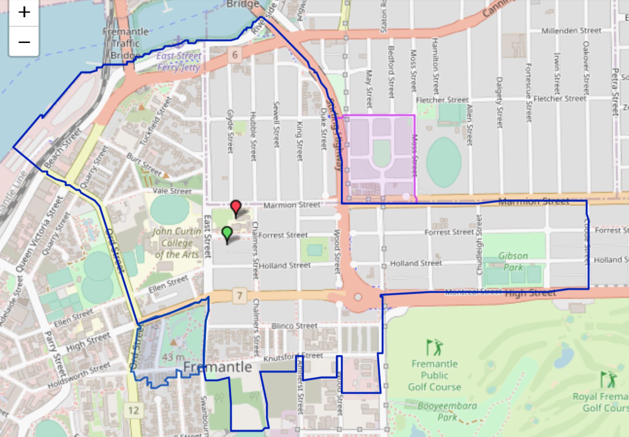
From the intersection of Stirling Highway and Marmion Street, east along Marmion Street to Coode Street, south along Coode Street to High Street, west along High Street to Montreal Street, south along Montreal Street to Knutsford Street, west along Knutsford Street to Swanbourne Street, north along Swanbourne Street to High Street, west along High Street to Ord Street, north along Ord Street to James Street, north west along James Street to the Fremantle Harbour, north east along Victoria Quay to the southern bank of the Swan River foreshore, north east along the Swan River foreshore to Stirling Bridge and Stirling Highway, south east and south along Stirling Highway to Marmion Street. The boundary parts of Marmion Street (south side), Coode Street (west side), High Street (eastern section, north side), Montreal Street (both sides), Knutsford Street (both sides), Swanborne Street (east side), High Street (western section, north side), Ord Street (east side), James Street (east side) and Stirling Highway (south west side) are included within this local intake area.
The dotted section on the top right is an optional area between East Fremantle Primary School and Richmond Primary School:
From the junction of Marmion Street and Moss Street, north along Moss Street to George Street, west along George Street and its extension to Stirling Highway, south along Stirling Highway to Marmion Street, and east along Marmion Street to Moss Street. The boundary parts of Moss Street (west side), George Street (south side), Stirling Highway (east side) and Marmion Street (north side) are included within this optional area.
The dotted section on the bottom left is an optional area between East Fremantle Primary School and Fremantle Primary School:
From the intersection of High Street and Ord Street, east along High Street to Swanbourne Street, south along Swanbourne Street to Knutsford Street, west along Knutsford Street to Ord Street and north along Ord Street to High Street. The boundary parts of High Street (south side), Swanbourne Street (west side), Knutsford Street (both sides) and Ord Street (east side) are included within this optional area.